Saturday, June 29, 2013

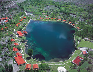
Shangrila Lake Pakistan

Shangrila Lake

Shangrila Lake or Lower Kachura Lake is a part of the Shangrila resort located at a drive of about 20 minutes from Skardu (nearly 2,500 m or 8,200 feet) town.
It is a popular tourist destination, and has a unique restaurant that is built on the fuselage of an aircraft that had crashed nearby.
Shangrila was established in 1983 with the opening of the first Resort Hotel in Skardu, Baltistan. Shangrila Resort Hotel was founded by the late Brig.(Retd) Muhammad Aslam Khan, the first commander of the Northern Scouts of the Pakistan Army.
Shangrila was named after a book titled "Lost Horizon" by James Hilton. In the novel, the author narrates a tale in which an aeroplane crash landed near a riverbed, in the early 1920s. The surviving passengers came across some Buddhist monks from a nearby temple and sought their help. They were taken to a beautiful lamasery filled with a variety of fruits and flowers. The monks looked quite young, although they claimed to be hundreds of years old. The idyllic place was called Shangri-la, a Tibetan word meaning "Heaven on earth".


Friday, June 28, 2013

Northern Light Banff National Park – Alberta, Canada

 Northern Light  Banff National Park 


An
 aurora is a natural light display in the sky particularly in the high latitude (Arctic and Antarctic) regions, caused by the collision of energetic charged particles with atoms in the high altitude atmosphere (thermosphere). The charged particles originate in the magnetosphere and solar wind and, on Earth, are directed by the Earth's magnetic field into the atmosphere. Most aurorae occur in a band known as the auroral zone, which is typically 3° to 6° in latitudinal extent and at all local times or longitudes. The auroral zone is typically 10° to 20° from the magnetic pole defined by the axis of the Earth's magnetic dipole. During ageomagnetic storm, the auroral zone expands to lower latitudes.Pictures of the aurora australis
Images of the aurora australis and aurora borealis from around the world, including those with rarer blue and red lights
Aurorae are classified as diffuse or discrete. The diffuse aurora is a featureless glow in the sky that may not be visible to the naked eye, even on a dark night. It defines the extent of the auroral zone. The discrete aurorae are sharply defined features within the diffuse aurora that vary in brightness from just barely visible to the naked eye, to bright enough to read a newspaper by at night. Discrete aurorae are usually seen in only the night sky, because they are not as bright as the sunlit sky. Aurorae occasionally occur poleward of the auroral zone as diffuse patches or arcs, which are generally invisible to the naked eye.
In northern latitudes, the effect is known as the aurora borealis (or the northern lights), named after the Roman goddess of dawn, Aurora, and the Greek name for the north wind, Boreas, by Pierre Gassendi in 1621. Auroras seen near the magnetic pole may be high overhead, but from farther away, they illuminate the northern horizon as a greenish glow or sometimes a faint red, as if the Sun were rising from an unusual direction. Discrete aurorae often display magnetic field lines or curtain-like structures, and can change within seconds or glow unchanging for hours, most often in fluorescent green. The aurora borealis most often occurs near the equinoctes. The northern lights have had a number of names throughout history. The Cree call this phenomenon the "Dance of the Spirits". In Medieval Europe, the auroras were commonly believed to be a sign from God.
Its southern counterpart, the aurora australis (or the southern lights), has features that are almost identical to the aurora borealis and changes simultaneously with changes in the northern auroral zone. It is visible from high southern latitudes in Antarctica, South America, New Zealand, and Australia. Aurorae occur on other planets. Similar to the Earth's aurora, they are visible close to the planet's magnetic poles. Modern style guides recommend that the names of meteorological phenomena, such as aurora borealis, be uncapitalized.


Friday, June 21, 2013

Galápagos Islands


The Galápagos Islands are an archipelago of volcanic islands distributed on either side of the Equator in the Pacific Ocean, 926 km (500 nmi) west of continental Ecuador, of which they are a part.
The Galápagos Islands and its surrounding waters form an Ecuadorian province, a national park, and a biological marine reserve. The principal language on the islands is Spanish. The islands have a population of slightly over 25,000.
The islands are famed for their vast number of endemic species and were studied by Charles Darwin during the voyage of the Beagle. His observations and collections contributed to the inception of Darwin's theory of evolution by natural selection.
The Galapagos Islands were discovered by chance on 10 March 1535, when the Dominican friar Fray Tomas de Berlanga, Bishop of Panama, went to Peru in pursuance of an order of the Spanish monarch, Charles V, to arbitrate in a dispute between Francisco Pizarro and his subordinates after the conquest of the Inca empire . Because of a calm and strong currents, the ship of the Bishop was dragged to the Galapagos. In chronicling his adventure, directed from Portoviejo Emperor Charles V on the discovery of the Galapagos Islands, Berlanga described the bleak desert conditions in the islands and the giant tortoises that inhabited them. He also described the marine iguanas, sea lions and many types of birds, emphasizing the unusual mildness of animals and expressed in the following words: Traxo the ship very good time breezes seven days, that the pilot haziase near the ground and calm diones six days the currents were so large, we engolfaron so that Wednesday March 10, we saw an island and because the ship had no more water for two days, agreed to take the boat and going ashore for water and grass for the horses. E hatched ... but found no sea lions, turtles and tortoises and so great a man wearing one above, and many who are like serpents higuanas. The first navigation chart of the islands was made by the buccaneer Ambrose Cowley in 1684. He named the individual islands after some of his fellow pirates or after the British noblemen who helped the privateer's cause. More recently, the Ecuadorian government gave most of the islands Spanish names. While the Spanish names are official, many users (especially ecological researchers) continue to use the older English names, principally because those were the names used when Charles Darwin visited.
Galápagos Islands
Name as inscribed on the World Heritage List
Map of the Galápagos archipelago
CountryEcuador
TypeNatural
Criteriavii, viii, ix, x
Reference1
UNESCO regionLatin America and the Caribbean
Inscription history
Inscription1978 (2nd Session)
Extensions2001 and 2003
Endangered2007–2010

Thursday, June 20, 2013

The Colosseum

The ColosseumColiseum, originally Flavian Amphitheatre , is a large amphitheatre in the city of Rome. The construction of the Colosseum started around 70—72 AD and was finished in 80 AD. Emperor Vespasian started the works, and Emperor Titus completed them. Emperor Domitian made some changes to the building between 81—96AD. It had seating for 50,000 people. It was 156 metres wide, 189 metres long and 57 metres tall. It is the biggest amphitheatre built by the Roman Empire.
The Colosseum was first called the Flavian Amphitheatre or in Latin, the Amphitheatrum Flavium. This was after Vespasian and Titus who had the family name of Flavius. It was used for gladiatorial contests, and other shows like animal hunts, in which animals would hunt and eat prisoners; or in which gladiators would fight against animals. There were also executions of prisoners, plays, and battle scenes; sometimes it was filled with water to fight sea battles. The people of Rome could go into the Colosseum without any costs; it was free.
In the Middle Ages it was no longer used for performances. It was then used as housing, workshops, a Christian shrine, and as a supply of building stones.
It has been worked out that about 500,000 people and over a million wild animals died in the Colosseum games.
It is now a ruin because of earthquakes and from people taking away the stones. The Colosseum is an iconic symbol of the Roman Empire. It is one of Rome's most popular tourist attractions. On Good Fridays, the Pope leads a torch lit "Way of the Cross" procession around the various levels of the amphitheatre.

The Colosseum in ancient Rome

The building of the Colosseum began under the rule of the Emperor Vespasian in around 70–72ACE. The area was flat, in a valley between the Caelian,Esquiline and Palatine Hills. There was a stream flowing through the valley, but this had been made into a canal. People had been living in this area for over 200 years, but the houses were destroyed in the Great Fire of Rome in 64ACE. The Emperor Nero took much of the land for his own use. He built a grand palace, the Domus Aurea which had a lake, gardens, paths covered with a roof held up by columns (porticoes), and large shelters (pavilions) to sit in. He had the Aqua Claudia aqueduct made longer to supply water to the area. There was also a big bronze statue of Nero, the Colossus of Nero, at the front of the Domus Aurea. In 68AD, Nero lost control of the government. The Senate made him a public outlaw, and he killed himself soon after.

Wednesday, June 19, 2013

Mount Everest

Mount Everest is the Earth's highest mountain, with a peak at 8,848 metres (29,029 ft) above sea level and the 5th tallest mountain measured from the centre of the Earth . It is located in the Mahalangur section of the Himalayas. The international border between China and Nepal runs across the precise summit point. Its massif includes neighboring peaks Lhotse, 8,516 m (27,940 ft); Nuptse, 7,855 m (25,771 ft) and Changtse, 7,580 m (24,870 ft).
In 1856, the Great Trigonometric Survey of British India established the first published height of Everest, then known as Peak XV, at 29,002 ft (8,840 m). In 1865, Everest was given its official English name by the Royal Geographical Society upon a recommendation by Andrew Waugh, the British Surveyor General of India. Waugh named the mountain after his predecessor in the post, Sir George Everest. Although Tibetans had called Everest "Chomolungma" for centuries, Waugh was unaware of this because Tibet and Nepal were closed to foreigners.
Mount Everest attracts many highly experienced mountaineers as well as capable climbers willing to hire professional guides. While not posing substantial technical climbing challenges on the standard route, Everest presents dangers such as altitude sickness, weather and wind.

Discovery

Mount Everest is located in Tibet.
Location on Earth
In 1802, the British began the Great Trigonometric Survey of India to determine the location and names of the world's highest mountains. Starting in southern India, the survey teams moved northward using giant theodolites, each weighing 500 kg (1,100 lb) and requiring 12 men to carry, to measure heights as accurately as possible. They reached the Himalayan foothills by the 1830s, but Nepal was unwilling to allow the British to enter the country because of suspicions of political aggression and possible annexation. Several requests by the surveyors to enter Nepal were turned down.
Published by the Survey of Nepal, this is Map 50 of the 57 map set at 1:50,000 scale "attached to the main text on the First Joint Inspection Survey, 1979–80, Nepal-China border." In the top center, note the boundary line, identified as separating "China" and "Nepal", passing exactly through the summit contour. The boundary here and for much of the China-Nepal border follows the main Himalayan watershed divide.
The British were forced to continue their observations from Terai, a region south of Nepal which is parallel to the Himalayas. Conditions in Terai were difficult because of torrential rains and malaria. Three survey officers died from malaria while two others had to retire due to failing health.
Nonetheless, in 1847, the British continued the Great Trigonometric survey and began detailed observations of the Himalayan peaks from observation stations up to 240 km (150 mi) away. Weather restricted work to the last three months of the year. In November 1847, Andrew Waugh, the British Surveyor General of India made several observations from the Sawajpore station located in the eastern end of the Himalayas. Kangchenjunga was then considered the highest peak in the world, and with interest he noted a peak beyond it, about 230 km (140 mi) away. John Armstrong, one of Waugh's officials, also saw the peak from a location farther west and called it peak "b". Waugh would later write that the observations indicated that peak "b" was higher than Kangchenjunga, but given the great distance of the observations, closer observations were required for verification. The following year, Waugh sent a survey official back to Terai to make closer observations of peak "b", but clouds thwarted all attempts.
In 1849, Waugh dispatched James Nicolson to the area, who made two observations from Jirol, 190 km (120 mi) away. Nicolson then took the largest theodolite and headed east, obtaining over 30 observations from five different locations, with the closest being 174 km (108 mi) from the peak.
Nicolson retreated to Patna on the Ganges to perform the necessary calculations based on his observations. His raw data gave an average height of 9,200 m (30,200 ft) for peak "b", but this did not consider light refraction, which distorts heights. However, the number clearly indicated, that peak "b" was higher than Kangchenjunga. Then, Nicolson contracted malaria and was forced to return home without finishing his calculations. Michael Hennessy, one of Waugh's assistants, had begun designating peaks based on roman numerals, with Kangchenjunga named Peak IX, while peak "b" now became known as Peak XV.
In 1852, stationed at the survey headquarters in Dehradun, Radhanath Sikdar, an Indian mathematician and surveyor from Bengal, was the first to identify Everest as the world's highest peak, using trigonometric calculations based on Nicolson's measurements. An official announcement that Peak XV was the highest was delayed for several years as the calculations were repeatedly verified. Waugh began work on Nicolson's data in 1854, and along with his staff spent almost two years working on the calculations, having to deal with the problems of light refraction, barometric pressure, and temperature over the vast distances of the observations. Finally, in March 1856 he announced his findings in a letter to his deputy in Calcutta. Kangchenjunga was declared to be 28,156 ft (8,582 m), while Peak XV was given the height of 29,002 ft (8,840 m). Waugh concluded that Peak XV was "most probably the highest in the world". Peak XV (measured in feet) was calculated to be exactly 29,000 ft (8,839.2 m) high, but was publicly declared to be 29,002 ft (8,839.8 m) in order to avoid the impression that an exact height of 29,000 feet (8,839.2 m) was nothing more than a rounded estimate..

Tuesday, June 18, 2013

Iguazu Falls

Iguazu Falls

Iguazu Falls, is waterfalls of the Iguazu River on the border of the Brazilian state of Paraná and the Argentinian province of Misiones. The falls divide the river into the upper and lower Iguazu. The Iguazu River rises near the city of Curitiba. It flows through Brazil for most of its course. Below its confluence with the San Antonio River, the Iguazu River forms the boundary between Argentina and Brazil.
The name "Iguazu" comes from the Guarani or Tupi words "y" , meaning "water", and "ûasú ", meaning "big". Legend has it that a god planned to marry a beautiful woman named Naipí, who fled with her mortal lover Tarobá in a canoe. In rage, the god sliced the river, creating the waterfalls and condemning the lovers to an eternal fall. The first European to find the falls was the Spanish conquistador Álvar Núñez Cabeza de Vaca in 1541.

On November 11 of 2011, Iguazu Falls was announced as one of the seven winners of the New Seven Wonders of Nature by the New Seven Wonders of the World Foundation

Geography[edit]

Union Fall, Iguazu's largest cataract
Iguazu Falls is located where the Iguazu River tumbles over the edge of the Paraná Plateau, 23 kilometres (14 mi) upriver from the Iguazu's confluence with the Paraná River. Numerous islands along the 2.7-kilometre-long (1.7 mi) edge divide the falls into numerous separate waterfalls and cataracts, varying between 60 to 82 metres (197 to 269 ft) high. The number of these smaller waterfalls fluctuates from 150 to 300, depending on the water level. About half of the river's flow falls into a long and narrow chasm called the Devil's Throat (Garganta del Diablo in Spanish or Garganta do Diaboin Portuguese). The Devil's Throat is U-shaped, 82 metres high, 150 m wide, and 700 m long (269×490×2,300 ft). Placenames have been given also to many other smaller falls, such as San Martin Falls, Bossetti Falls and many others.
Iguazú Falls from the Argentine side
About 900 metres (2,950 ft) of the 2.7-kilometre (1.7 mi) length does not have water flowing over it. The edge of the basalt cap recedes by 3 mm (0.1 in) per year. The water of the lower Iguazu collects in a canyon that drains in the Paraná River, a short distance downstream from the Itaipu Dam. The junction of the water flows marks the border between Brazil, Argentina, and Paraguay. There are points in the cities of Foz do Iguaçu, Brazil, Puerto Iguazú, Argentina, and Ciudad del Este, Paraguay, which have access to the Iguazu River, where the borders of all three nations can be seen, a popular tourist attraction for visitors to the three cities.

Distribution of the Falls between Argentina and Brazil[edit]

The Iguazu Falls are arranged in a way that seems like a reverse letter "J". The border between Brazil and Argentina runs through the Devil's Throat. On the right bank is the Brazilian territory, which has just over 20% of the jumps of these falls, and the left side jumps are Argentine, which make up almost 80% of the falls.

Tourism[edit]

Panorama of the falls
There are two international airports close to Iguazú Falls: the Argentine Cataratas del Iguazú International Airport (IGR) and the Brazilian Foz do Iguaçu International Airport (IGU). Argentina's airport is 25 kilometres (16 mi) from the city of Iguazu but closer to the Falls hotels than its Brazilian counterpart. There is bus and taxi service from and to the Airport-Falls. Brazil's airport is between Foz do Iguaçu, Brazil and the falls. LAN Airlines and Aerolíneas Argentinas have direct flights from Buenos Aires to Iguazu International Airport Krause. Several Brazilian airlines, such as TAM Airlines, GOL,Azul, WebJet, offer service from the main Brazilian cities to Foz do Iguaçu.

Monday, June 17, 2013

Mont-Saint-Michel, France

Mont-Saint-Michel,

Mont Saint-Michel is a rocky tidal island 247 acres (100 ha) in size, and is a commune in Normandy, France. It is located approximately one kilometre (just over half a mile) off the country's northwestern coast, at the mouth of the Couesnon River near Avranches. The island's highest point is 92 metres (301 feet) above sea level. The population of the island is 44, as of 2009.
The island has held strategic fortifications since ancient times, and since the eighth century AD has been the seat of the monastery from which it draws its name. The structural composition of the town exemplifies the feudal society that constructed it. On top God, the abbey and monastery, below this the Great halls, then stores and housing, and at the bottom, outside the walls, fishermen and farmers housing.
One of France's most recognisable landmarks, Mont Saint-Michel and its bay are part of the UNESCO list of World Heritage Sites and more than 3 million people visit it each year.
Le Mont Saint-Michel
Mont St Michel 3, Brittany, France - July 2011.jpg
Le Mont Saint-Michel
Coat of arms of Le Mont Saint-Michel
Le Mont Saint-Michel is located in France
Le Mont Saint-Michel
Administration
CountryFrance
RegionLower Normandy
DepartmentManche
ArrondissementAvranches
CantonPontorson
IntercommunalityCommunauté de communes de Pontorson - Le Mont-Saint-Michel
MayorÉric Vannier
(2008–2014)
Statistics
Elevation5–80 m (16–260 ft)
Land area10.97 km2 (0.37 sq mi)
Population242  (2008)
 - Density43 /km2 (110 /sq mi)
INSEE/Postal code50353/ 50116
1 French Land Register data, which excludes lakes, ponds, glaciers > 1 km² (0.386 sq mi or 247 acres) and river estuaries.
2 Population without double counting: residents of multiple communes (e.g., students and military personnel) only counted once.

Geography 

Formation[edit]

In prehistoric times the bay was land. As sea levels rose, erosion shaped the coastal landscape over thousands of years. Several blocks of granite or granulite emerged in the bay, having resisted the wear and tear of the ocean better than the surrounding rocks. These included Lillemer, the Mont-Dol, Tombelaine (the island just to the north), and Mont Tombe, later called Mont Saint-Michel. The Mont has a circumference of about 960 meters and 92 meters at its highest

Tides[edit]

The tides in the area change quickly, and have been described by Victor Hugo as swiftly as a galloping horse".
The tides can vary greatly, at roughly 14 metres (46 ft) between high and low water marks. Popularly nicknamed "St. Michael in peril of the sea" by medieval pilgrims making their way across the flats, the mount can still pose dangers for visitors who avoid the causeway and attempt the hazardous walk across the sands from the neighbouring coast.
Polderisation and occasional flooding created salt marsh meadows that were found to be ideally suited to grazing sheep. The well-flavoured meat that results from the diet of the sheep in the pré salé (salt meadow) makes agneau de pré-salé (salt meadow lamb), a local specialty that may be found on the menus of restaurants that depend on income from the many visitors to the mount.

Tidal island[edit]

Low tide in 2005
Mont Saint-Michel was previously connected to the mainland via a tidal causeway, i.e., a trackway covered at high tide and revealed at low tide. This connection has been altered over the centuries. The coastal flats have been polderised to create pastureland, thus the distance between the shore and the south coast of Mont Saint-Michel has decreased, and the Couesnon River has been canalised, reducing the dispersion of the flow of water, and thereby encouraging a silting-up of the bay. In 1879, the tidal causeway was converted into a raised or dry causeway. This prevented the tide from scouring the silt around the mount.
On 16 June 2006, the French prime minister and regional authorities announced a €164 million project (Projet Mont-Saint-Michel) to build a hydraulic dam using the waters of the river Couesnon and of tides to help remove the accumulated silt deposited by the rising tides, and to make Mont Saint-Michel an island again. It was projected to be completed by 2015.
The construction of the dam began in 2009 and is now complete. The project also included the removal of the causeway and its visitor car-park. It will be replaced by a light bridge, allowing the waters to flow freely around the island, which will improve the efficiency of the now operational dam, and a replacement car-park on the mainland. Visitors will use small shuttles to cross the future bridge which will still be open to pedestrians and unmotorised vehicles.

Sunday, June 16, 2013

Los Glaciares National Park, Argentina

Los Glaciares National Park

Parque Nacional Los Glaciares (Spanish: The Glaciers) is a national park in the Santa Cruz Province, in Argentine Patagonia. It comprises an area of 4459 km². In 1981 it was declared a World Heritage Site by UNESCO.
The national park, created in 1937, is the second largest in Argentina. Its name refers to the giant ice cap in the Andes range that feeds 47 large glaciers, of which only 13 flow towards the Atlantic Ocean. The ice cap is the largest outside of Antarctica and Greenland. In other parts of the world, glaciers start at a height of at least 2,500 meters above mean sea level, but due to the size of the ice cap, these glaciers begin at only 1,500m, sliding down to 200m AMSL, eroding the surface of the mountains that support them.

Geography

Walkways close to Perito Moreno Glacier.jpg
Los Glaciares, of which 30% is covered by ice, can be divided in two parts, each corresponding with one of the two elongated big lakes partially contained by the Park. Lake Argentino, 1,466 km² and the largest in Argentina, is in the south, while Lake Viedma, 1,100 km², is in the north. Both lakes feed the Santa Cruz River that flows down to Puerto Santa Cruz on the Atlantic. Between the two halves is a non-touristic zone without lakes called Zona Centro.
The northern half consists of part of Viedma Lake, the Viedma Glacier and a few minor glaciers, and a number of mountains very popular among fans of climbing and trekking, including Mount Fitz Roy and Cerro Torre.
The southern part has, as well as a number of smaller ones, the major glaciers which flow into Lake Argentino: Perito Moreno Glacier,Upsala Glacier, and Spegazzini Glacier
. Typical excursion boats travel between icebergs to visit Bahía Onelli, and the otherwise inaccessible Spegazzini and Upsala. The Perito Moreno is reachable by land
Los Glaciares National Park
IUCN category II (national park)

Walkways heading Perito Moreno Glacier
LocationSanta Cruz Province, Argentina
Coordinates50°0′0″S 73°14′58″W
Area4459 km²
Established1937
Governing bodyAdministración de Parques Nacionales
UNESCO World Heritage Site
Official name: Los Glaciares
Type:Natural
Criteria:vii, viii
Designated:1981 (5th session)
Reference No.145
State Party:Argentina
Region:Latin America and the Caribbean

Human Activity 


Los Glaciares is a major attraction for international tourists, and has an annual budget of one million dollars (1994). Starting points of tours are the village of El Calafate at the shore of Lake Argentino but outside the park, where the park's administration has its headquarters, and El Chaltén village in the northern part of the park, at the foot of the Fitz Roy. Other touristic points in the park include Lago del Desierto and Lago Roca.

Friday, June 14, 2013

Mount Fuji, Honshu Island, Japan

 Mount Fuji

Mount Fuji, located on Honshu Island, is the highest mountain in Japan at 3,776.24 m (12,389 ft). An active stratovolcano that last erupted in 1707–08, Mount Fuji lies about 100 kilometres (60 mi) south-west of Tokyo, and can be seen from there on a clear day. Mount Fuji's exceptionally symmetrical cone, which is snow-capped several months a year, is a well-known symbol of Japan and it is frequently depicted in art and photographs, as well as visited by sightseers and climbers. It is one of Japan's "Three Holy Mountains" along with Mount Tate and Mount Haku; it is a Special Place of Scenic Beauty, a Historic Site, and has been submitted for future inscription on the World Heritage List as a Cultural (rather than Natural) Site
Mount Fuji
01 Fujisan from Yamanakako 2004-2-7.jpg
Mount Fuji reflected on Lake Yamanaka
Elevation3,776 m (12,388 ft)
Prominence3,776 m (12,388 ft)
Ranked 35th
ListingHighest peak in Japan
Ultra
List of mountains in Japan
100 Famous Japanese Mountains


Location
Mount Fuji is located in Japan
Mount Fuji
Chūbu region, Honshu, Japan
Coordinates35°21′28.8″N 138°43′51.6″E
Topo mapGeospatial Information Authority25000:1
50000:1 
Geology
TypeStratovolcano
Last eruption1707-08
Climbing
First ascent663 by an anonymous monk
Easiest routeHiking

History


Mount Fuji is an attractive volcanic cone and a frequent subject of Japanese art especially after 1600, when Edo became the actual capital and people saw the mountain while traveling on the Tōkaidō-road. Among the most renowned works are Hokusai's 36 Views of Mount Fuji and his One Hundred Views of Mount Fuji. The mountain is mentioned in Japanese literature throughout the ages and is the subject of many poems.
It is thought that the first ascent was in 663 by an anonymous monk. The summit has been thought of as sacred since ancient times and was forbidden to women until the Meiji Era. Ancient samurai used the base of the mountain as a remote training area, near the present day town of Gotemba. The shogun Minamoto no Yoritomo held yabusame in the area in the early Kamakura period.
The first ascent by a foreigner was by Sir Rutherford Alcock in September 1868, from the foot of the mountain to the top in eight hours and three hours for the descent. Alcock's brief narrative in The Capital of the Tycoon was the first widely disseminated description of the mountain in the West. Lady Fanny Parkes, the wife of British ambassador Sir Harry Parkes, was the first non-Japanese woman to ascend Mount Fuji in 1869. Photographer Felix Beato climbed Mount Fuji in the same year.
Today, Mount Fuji is an international destination for tourism and mountain-climbing. In the early 20th century, populist educator Frederick Starr's Chautauqua lectures about his several ascents of Mount Fuji—1913, 1919, and 1923—were widely known in America. A well-known Japanese saying suggests that anybody would be a fool not to climb Mount Fuji once—but a fool to do so twice. It remains a popular meme in Japanese culture, including making numerous movie appearances, inspiring the Infiniti logo, and even appearing in medicine with the Mount Fuji sign.
In September 2004, the manned weather station at the summit was closed after 72 years in operation. Observers monitored radar sweeps that detected typhoons and heavy rains. The station, which was the highest in Japan at 3,780 metres (12,402 ft), was replaced by a fully automated meteorological system.
In early 2013, various sources suggested that the magma chamber pressure could lead to an eruption "in early 2015 or sooner" of VEI 5 or 6 depending on how the pressure is released. Effects could range from regional air disruption comparable to the Icelandic volcano, Grímsvötn of 2011 to a catastrophe rivaling the destruction of Krakatoa (Krakatau) causing worldwide climatic disruption for years.
Some theories also suggest that magnetic field "bucks" precede large eruptions as the magma circulation generates a mini magnetosphere in much the same way as the Earth's field is generated. This could also explain the frequent reports of fireballs and "earthquake lights" as ionised gas from volcanic vents is formed into self-sustained plasma vortices which can persist for hours if conditions are right.
As of 2011, the Japan Self-Defense Forces and the United States Marine Corps continue to operate military bases near Mount Fuji.

Climate[edit]

The summit of Mount Fuji has a tundra climate . The temperature is very low at the high altitude, and the cone is covered by snow for several months of the year. The lowest recorded temperature is −38.0 °C recorded in February 1981, and the highest temperature was 17.8 °C recorded in August 1942.

Climate data for Mount Fuji Averages (1981–2010) Records (1932–2011)
MonthJanFebMarAprMayJunJulAugSepOctNovDecYear
Record high °C (°F)−1.7
(28.9)
0.0
(32)
1.0
(33.8)
4.7
(40.5)
12.2
(54)
12.3
(54.1)
17.4
(63.3)
17.8
(64)
16.3
(61.3)
10.4
(50.7)
6.9
(44.4)
3.6
(38.5)
17.8
(64)
Average high °C (°F)−15.7
(3.7)
−14.7
(5.5)
−10.9
(12.4)
−5.7
(21.7)
−0.8
(30.6)
3.6
(38.5)
7.5
(45.5)
9.3
(48.7)
6.1
(43)
−0.1
(31.8)
−6.4
(20.5)
−12.2
(10)
−3.4
(25.9)
Daily mean °C (°F)−18.4
(−1.1)
−17.8
(0)
−14.2
(6.4)
−8.7
(16.3)
−3.4
(25.9)
1.1
(34)
4.9
(40.8)
6.2
(43.2)
3.2
(37.8)
−2.8
(27)
−9.2
(15.4)
−15.1
(4.8)
−6.2
(20.8)
Average low °C (°F)−21.7
(−7.1)
−21.5
(−6.7)
−17.8
(0)
−12.1
(10.2)
−6.5
(20.3)
−1.6
(29.1)
2.4
(36.3)
3.6
(38.5)
0.4
(32.7)
−5.8
(21.6)
−12.2
(10)
−18.3
(−0.9)
−9.3
(15.3)
Record low °C (°F)−37.3
(−35.1)
−38
(−36)
−33.9
(−29)
−27.8
(−18)
−18.9
(−2)
−13.1
(8.4)
−6.9
(19.6)
−4.3
(24.3)
−10.8
(12.6)
−19.5
(−3.1)
−28.1
(−18.6)
−33
(−27)
−38
(−36)
 % humidity--58606170797368535047-